


وصف لـ Marine Navigation Lite
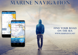
Are you one of those who prefers travelling by their own boat, but worried about getting lost in the ocean? Marine Navigation is one of the best sea GPS trackers which lets you find your road on the sea. It provides one of the most accurate and detailed GPS plotters and is a perfect GPS Chartplotter for boating and sailing.
Marine Navigation comes with everything you should expect from such boating and GPS navigation in sea apps, and it also comes with a super user-friendly and intuitive interface. You just need to browse through different menus of this sea navigation app to completely get the whole idea and get used to working with it. Your ultimate GPS tracker tool is not just about finding the best route while traveling in the sea, as it offers so many other cool features including:
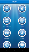
Morse Code in case of danger, Anchor Alert to prevent the drift of the anchor, Moon Phase to show the phases of the moon during the day, Harbors to see the list of ports, Sync Waypoints to be able to create backups and access them from different devices, and Group to go social and share your insights with friends and family.
You also get to download the maps and marine charts, so you won’t need an active internet connection when it comes to getting navigation and route planning. If you create a profile, you can save waypoints and routes to access them from different devices. All you have to do is logging in with the same account and enjoy seamless sea GPS navigations.
So, no matter you are a professional sailor or fisherman, or you are an amateur who like traveling in the sea, Marine Navigation has got you covered. It’s a versatile sea navigator app and boating route planner which provides accurate GPS Chartplotter and marine charts. The Social feature is a fun feature which enables you to communicate with different people all around the world who happens to have so many things in common with you, including loving seas, traveling, boating, and sailing.
Marine Navigation: GPS Tracker Main Features at a Glance:
•Super easy to use GPS tracker tool
•Clean and neat design
•Available in different languages: English, Italian, French, Spanish, Brazilian, Turkish, Indonesian and German
•Download Maps to use in offline mode
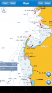
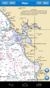
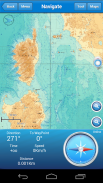
•Accurate and detailed GPS Chartplotter, GPS plotter and Marine charts
•Optimized for phones and tablets
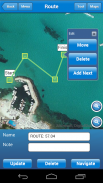
•Sync routes and waypoints to access them anywhere from any devices
•Moon phase
•Morse Code
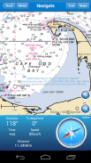
•Receive information about speed, direction, time to arrival
•Compass
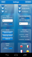
•Change Measurement Units: Km, Mi, or Nmi
•Social Feature to share waypoints, images, insights, and live chat
Marine Navigation offers so many features to make sure you don’t need any extra sea GPS tracker tools to carry. It comes with everything you need and you no longer need to worry about finding the route or being lost between waypoints. The Offline Mode lets you freely download the maps and areas and enjoy sea navigation without any connection. The easy to use and learn interface makes sure everyone can get the most out of this sailing GPS app.
Download Marine Navigation and let us know about any bugs, feature requests or any other suggestions. Stay tuned for more features and options in this GPS tracker app for boating.
MAPS AND MARINE CHARTS
More Details: http://www.fishpoints.net/mapsview/
هل أنت واحد من أولئك الذين تفضل السفر عن طريق القوارب الخاصة بهم، ولكن قلق التخبط في المحيط؟ التنقل البحرية هي واحدة من أفضل تعقب GPS البحر التي تمكنك من العثور على الطريق الخاص على البحر. ويوفر واحدة من المتآمرين الأكثر دقة وتفصيلا GPS وهو Chartplotter GPS مثالية لركوب الزوارق والمراكب الشراعية.
الإنتقال البحرية يأتي مع كل ما يجب أن تتوقع من هؤلاء القوارب والملاحة GPS في تطبيقات سطح البحر، ويتعلق الأمر أيضا مع سهلة الاستخدام وبديهية واجهة السوبر. كل ما تحتاجه لتصفح القوائم المختلفة لهذا التطبيق الملاحة البحرية للحصول تماما الفكرة كلها والتعود على العمل معها. الخاص بك في نهاية المطاف أداة GPS تعقب لا يقتصر فقط على إيجاد أفضل السبل أثناء السفر في البحر، كما أنها توفر العديد من الميزات الرائعة الأخرى بما في ذلك:
مورس في حالة الخطر، مرساة تنبيه لمنع انجراف مرساة، المرحلة القمر لعرض مراحل القمر خلال النهار المرافئ لرؤية قائمة المنافذ، مزامنة نقاط الطريق لتكون قادرة على إنشاء نسخ احتياطية والوصول إليها من أجهزة مختلفة، و مجموعة لتذهب الاجتماعية وشارك أفكارك مع العائلة والأصدقاء.
يمكنك أيضا الحصول على تحميل الخرائط والرسوم البيانية البحرية، لذلك فإنك لن تحتاج إلى اتصال إنترنت نشط عندما يتعلق الأمر بالحصول على التخطيط الملاحة والتوجيه. إذا قمت بإنشاء الشخصي، يمكنك حفظ نقاط الطرق والطرق للوصول إليها من الأجهزة المختلفة. كل ما عليك القيام به هو تسجيل الدخول بنفس حساب والتمتع سلس الملاحة GPS البحر.
لذا، مهما كنت بحار المهنية أو صياد، أو كنت من هواة الذين يحبون السفر في البحر، التنقل البحرية وحصلت على تغطيتها. انها تنوعا التطبيق الملاح البحر والقوارب مخطط الطريق التي تنص دقيقة Chartplotter GPS والخرائط البحرية. و الاجتماعية ميزة هي ميزة ممتعة والتي تمكنك من التواصل مع مختلف الناس في جميع أنحاء العالم الذين يحدث لديهم أشياء كثيرة مشتركة مع لكم، بما في ذلك البحار المحبة، والسفر، وركوب الزوارق، والإبحار.
التنقل البحري: ملامح GPS المقتفي الرئيسية في لمحة:
والثور؛ سوبر سهلة الاستخدام GPS أداة تعقب
والثور، نظيفة وتصميم أنيق
والثور؛ متاح في لغات مختلفة: الانجليزية والايطالية والفرنسية والاسبانية والبرازيلية والتركية والإندونيسية والألمانية
والثور؛ تحميل خرائط لاستخدامها في وضع دون اتصال
والثور؛ دقيق ومفصل Chartplotter GPS، GPS الراسمة والبحرية الرسوم البيانية
والثور؛ الأمثل للهواتف والأجهزة اللوحية
والثور؛ وطرق مزامنة ونقاط الطرق للوصول إليها في أي مكان من أي من الأجهزة
والثور؛ المرحلة القمر
& الثور؛ مورس
والثور؛ تلقي المعلومات حول السرعة والاتجاه، وقت الوصول
& الثور؛ البوصلة
والثور؛ تغيير وحدات القياس: كم، مي، أو NMI
والثور؛ ميزة الاجتماعية لتبادل نقاط الطرق والصور والرؤى، والدردشة الحية
التنقل البحرية يقدم العديد من الميزات للتأكد من أنك لا تحتاج إلى أي أدوات GPS تعقب البحر اضافية حملها. لأنه يأتي مع كل ما تحتاجه وأنت لم تعد بحاجة للقلق حول العثور على الطريق أو الضياع بين نقاط الطريق. و وضع غير متصل يتيح لك بحرية تحميل الخرائط والمناطق والتمتع الملاحة البحرية دون أي اتصال. سهل الاستخدام والتعلم واجهة يجعل متأكد من أن الجميع يمكن الحصول على أقصى استفادة من هذا التطبيق الإبحار GPS.
تحميل التنقل البحرية و إخبارنا عن أي البق، طلبات جديدة أو أي اقتراحات أخرى. ترقبوا المزيد من الميزات والخيارات في هذا GPS التطبيق تعقب القوارب.
الخرائط والرسوم البيانية MARINE
تفاصيل أخرى: http://www.fishpoints.net/mapsview/
Marine Navigation Lite - إصدار 6.3.22
(12-07-2021)
Marine Navigation Lite - معلومات APK
نُسخة APK: 6.3.22الحزمة: air.it.palaferri.fishpointsamerigoLiteتطبيقات من الفئة نفسها
قد يعجبك أيضًا...


